|
|
|
PART I -- Dreaming Big By Mark McGuigan The first of four parts September 28 -- Four thousand feet from the Santa Monica shoreline, the murky depths of the Pacific Ocean churn with life. The ocean floor, lying at a depth of approximately 60 feet, is home to some 5,000 species of marine life quietly going about their business. Forty years ago it was considered a perfect place to build a highway. For years the audacious scheme to create a chain of islands linked by a causeway lay dormant, hidden in a cardboard box in the vaults of City Hall. Before fading from memory, the ghost of this white elephant continued to stalk City Hall until the 70s, when a scale model of the project, sitting in the planning office, mysteriously disappeared.
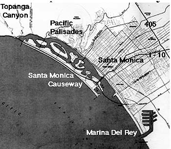
But the image of a Santa Monica that never was recently resurfaced when City Clerk Maria Stewart, who was looking for ways to save money by consolidating documents, pulled the old files. The files outlined a plan so expensive it would cost nearly half of what the city was worth, so big it would stretch nearly six miles (longer than the breath of Santa Monica) and so improbable, it would never go beyond the page. *** The story begins in 1961, when Santa Monica found itself between a rock and a soft, watery place. One of the main passages to beachfront paradise, the narrow, four-lane Pacific Coast Highway (PCH), carved from the side of the Santa Monica Mountains, was constantly choked with traffic. Studebakers, Chevrolets, Oldsmobile and Comets -- steel barges on wheels -- all vied for space on the four-lane strip of asphalt running along the coast. Reflecting the fate of modern day California, north-south traffic was grid locked. “The traffic was heavy,” recalls former City Council member Jim Reidy who was a member of the Junior Chamber of Commerce at the time. “In that area they had slides all along the Santa Monica portion (of the highway), and the road at times would be just totally blocked with rocks.” Rockslides had always been a common feature of PCH. Even a minor rock fall forced drivers to seek alternate routes. Cars trying to avoid the crush on the coastal road would often drive up 26th Street to Sunset Boulevard, the only viable alternative. The result was nothing short of chaos. “Sunset was carrying the whole load of PCH as well as its normal traffic, and it was just blocked -- you couldn’t get through,” Reidy explains. And even in the early sixties, California’s love affair with the automobile was so strong that the very thought of drivers relinquishing control of the steering wheel was anathema to many motorists. The solution to Santa Monica’s escalating traffic problem was therefore obvious -- the city needed more road space. There were already many projects taking place throughout the state, and the California Division of Highways had been studying the problem of congestion along Pacific Coast Highway between Malibu Point and Santa Monica for years and had so far come up with three possible solutions. The first option was to build a thoroughfare in the mountain area east of the existing highway. To achieve any sort of workable roadway, property would have to be bought to make room for construction, and the California Division of Highways had the financial clout to do just that. In those postwar days, the sky-high gasoline prices had given the government money to burn. “The word was out that CalTrans (California Division of Highways) was buying property in Malibu -- actually buying it,” says architect Jim Mount, a longtime civic leader. As the Division of Highways began to snap up property, alarm bells rang in City Hall. Santa Monica had already been sliced in half by a plan to build a new freeway through the city (which would later become the I-10) and the last thing people wanted was another freeway quartering the land. “The scuttlebutt was that they were going to have a bridge across the canyon in Huntington Palisades and it would ruin Pacific Palisades and cut Santa Monica in half again so that it would be quartered by CalTrans,” explains Mount. “There was already a biggish size reaction to their running the Santa Monica Freeway right through" the city. A second alternative on the Division of Highway’s drawing board called for the construction of a road just west of PCH that was closer to the beach. “The freeway was going to come into Santa Monica and then the freeway would have to go somewhere,” explains Jim Lunsford, a Planning Technician in the city at the time. “It would have to go up the coast, so CalTrans was talking about taking out the houses along the beach.” But this wasn’t going to happen. Few property owners were willing to give up their prime beachfront property to make way for a new road. That left one other option. The third idea was a little more far-fetched, and on paper read very much like something dreamed up late one Friday evening before leaving the office. If the Highway Division couldn’t build further inland or on the beach, why not just build the road off the coast in the middle of the ocean? It was this idea that grabbed the attention of local businessman John Drescher. “I remember John was real active in promoting this thing,” says Reidy. “He was always active in stuff.” *** Though it sounded outlandish, Drescher was just the sort of man who could see the particular advantages to such a plan. He had graduated from the University of Colorado in 1932 with honors in electrical engineering and moved to Santa Monica in 1938 to work as a pilot and a design engineer for aircraft components. When America entered the war in 1941, the then 30-year old Drescher became a consultant for the War Department developing an important bomb release mechanism used on Douglas aircraft. “He was a kind of a visionary type guy especially when he was younger,” says former Director of General Services for the city Stan Scholl of his old friend. “He had several patents in some of those things he made.” In fact Drescher held nine patents related to his design work and by 1944 had established his own company, Drescher Engineering in Santa Monica, a business venture that would later make him a generous, if somewhat eccentric, millionaire. “He was kind of like a hermit,” recalls Scholl. “He lived on his industrial property with his bird, a parakeet.” Despite his odd choice of living accommodation, Drescher was very active in the local community, had an abundance of friends, a quick wit and an ability to spin a yarn. He could also see possibilities where others couldn’t -- here was the man with a plan. Along with the company Seaway Enterprises Incorporated of Beverly Hills, Drescher crafted an ambitious scheme. On July 19, 1961, Seaway Enterprises presented the City Council with a thirty-page document, complete with artist renderings, proposing the construction of an island causeway off the coast. Located 4,000 feet from shore, the 30,000-foot long causeway would run parallel to the coastline from Santa Monica beach all the way north to Malibu. In the middle of this artificial archipelago would stretch a 200-foot wide freeway called “Sunset Seaway.”
It was a remarkable concept. Not only would the brand new highway alleviate the pressure on the coastal road but it would also provide an additional 2.5 million square feet of public beach facing the ocean. The new beaches would accommodate “up to 50,000 persons on peak days,” according to the Seaway Enterprises document. In addition to the new land, the area of water between the natural shoreline and the artificial causeway would become a series of marinas accommodating 1,700 small craft. “The biggest promoting features was that one, it would reduce the highway problems and two, it would create a long harbor where small boats could sail without getting involved in the ocean,” says Reidy of the proposal. On August 29 1961, with City Manager Ernest N. Mobley leading the charge, the City Council established a Causeway and Freeway Committee to “consider and recommend on the desirability and feasibility of the causeway proposal made by Seaway Enterprises and/or any similar proposal.” “The council for a time had a causeway committee that met in council chambers and discussed and debated the whole causeway question,” recalls Santa Monica businessman John Bohn who was a member of the City Council at the time. “Most of the pros and cons, the pluses and minuses, took place at the causeway committee meeting,” he said. The committee comprised seven members, a motion picture producer who himself owned a beachfront home, an investment broker, an attorney, a technical writer, a wholesale food company manager, a planning consultant and an architect. These were the movers and the shakers in the community, just the crew to get the job done. Their names were Chairman Richard Wilson, Kenneth Hodges, Leo Holliday, James Mount, James O’Brien, William G. Wells and Thomas Zimmerman. “There were seven of us on the commission,” recalls Mount the architect of the group. “That’s the normal commission number for the city of Santa Monica. It’s got to be odd if there’s a tie-breaker and enough of them so that they’ll be there,” he said laughing. *** One of the most challenging questions facing committee members was: “Where would all the rock come from?” When the Santa Monica breakwater was constructed in the early thirties, quarry stone had been shipped in barges all the way from Catalina Island. “It came across on barges that were towed by tugs and then dumped into the bay at the side of the breakwater,” says Bohn. “It takes a lot of rock to build a causeway.” In the case of Sunset Seaway, the estimated tonnage clocked in at a staggering 97 million cubic yards of landfill for the causeway alone and an additional 2.5 million tons of rock to construct a submerged reef to protect it. “The commission was to investigate how landfill could provide another place for CalTrans to go with their inevitable freeway,” said Mount. “Here was an opportunity to get the darn thing out to sea by using the grading material that was coming out of the Santa Monica Mountains.” According to Drescher’s proposal, the causeway would be a phased operation. Rock from the nearby mountains would first be used to create a protective reef. Once in place, the initial landfill for the causeway would come from terracing the mountains, creating an ideal location for new property while at the same time providing some much-needed tonnage. “The best method of moving this material to the site would be by belt conveyor from the terraces to barges at a specially designed loading area,” the document proclaims. But such a conveyor system would have to cross over Pacific Coast Highway; not only would the highway be subject to natural rockslides, but the new plan now called for millions of tons of rock to pass over the heads of motorists below. To allay fears the document assured the commission that “with adequate scaffolding and decking to protect the roadway below against falling rock and dirt,” things would be just fine. The idea was a hit with the council and commission alike. Very soon the image of the causeway started cropping up in other places. An old poster for Douglas Aircraft shows a new airplane design flying high above Santa Monica and in the background, like some ghostly image of Atlantis, sits the causeway. “There was support for the causeway from people well outside Santa Monica,” says Reidy. “It was the Santa Monica dream.” “It got everybody’s fancy,” says Mount. “I could see a wonderful breakwater here with boats and sailboats and pleasure craft of all kinds, with people living on the shore.” The causeway would be a glittering jewel in the crown of the Santa Monica, and with rock from the mainland, it would be a chip off the old block. Now all the commission needed was a cost estimate and an engineering firm with the wherewithal to draw up a suitable plan. Next: The Tide Turns |
Copyright 1999-2008 surfsantamonica.com. All Rights Reserved. |
|